Campus Map and Directions

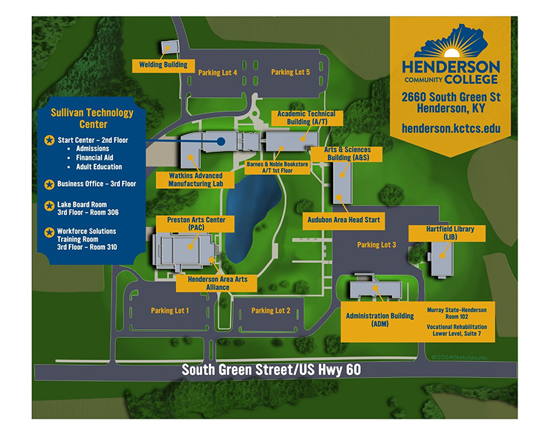
HCC CAMPUS Building Key
ADM - Hecht S. Lackey Administration Building
A&S - Robert English Arts and Sciences Building
A/T - Academic Technical Building
PAC - Preston Arts Center
LIB - Joseph M. Hartfield Library
STC - William L. Sullivan Technology Center
WLD - Welding Building
To reach our main campus in Henderson:
U.S. Highway 41 going south from Evansville, IN:
Take the Henderson, U.S. 60 west exit (15B) also known as Green Street, continue 6
miles through town and the industrial park. After the stoplight at the intersection
of 425 Bypass and Highway 60, turn left at any of the three entrances to Henderson
Community College.
I-69 going north from Madisonville:
Take the Morganfield exit (Exit 148A)--425 Bypass (Henderson Community College and
State Police). Continue on 425 Bypass through the 2 stoplights, Hwy. 41 & Hwy. 41A,
until the 3rd stoplight at the intersection of 425, Hwy. 136 and U.S. 60 west. Turn
left onto U.S. 60 west. Then turn left at any of the three entrances to Henderson
Community College.
Audubon Parkway from Owensboro:
Take the Madisonville exit, going south on US 41 (formerly the Pennyrile Parkway).
Take the Morganfield and State Police exit (Exit 10A)--425 Bypass. Continue on 425
Bypass through the 2 stoplights, Hwy. 41 & Hwy. 41A, until the 3rd stoplight at the
intersection of 425, Hwy. 136 and U.S. 60 west. Turn left onto U.S. 60 west. Then
turn left at any of the three entrances to Henderson Community College.
Main Entrance: Sullivan Technology Building Welcome Center
The main entrance to college can be accessed by turning south onto Old Corydon Road
from the 425 Bypass and then onto Sandy Watkins Way.
